
 Marshall Rare Books
Certain Errors in Navigation, Detected and Corrected by Edw:Wright with many additions that were not in the former editions.
This edition is important: “What made this edition…into a navigation manual suitable for all seamen was the inclusion [for the first time] of a translation made by a friend, of a standard Spanish navigation manual of 1588, Zamorano’s Compendio del Arte de Navigar.” Waters, p. 317.
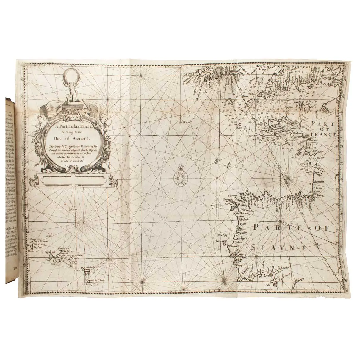
London: Joseph Moxon, 1657. Small 4to (210 x 160mm) Finely engraved title, incorporating a world map on Mercator’s projection; large folding map of the Azores, 4 folding plates of instruments, diagrams etc.& 27 woodcut illus., many of instruments, in the text, pp. (26), 224, 110,(2), Contemporary panelled calf gilt, rebacked, some marginal damp stains towards the end of the volume, otherwise this is a crisp, unpressed copy.
Third edition, corrected and enlarged, of the most important and most influential English book on the art of navigation, “a book that set the seal on the supremacy of the English in the theory and practice of the art of navigation at this time. It contained a brilliant summary of all the chief contemporary practices of navigation together with a critical examination of their faults, and either the actual means for eliminating them or else sound guidance on the measures necessary to do away with them…
“Wright’s Certaine Errors was so packed with learning, was such an able survey of navigation practice at the close of the sixteenth century, and by its chart projection introduced such order out of the former cartographical confusion, that it and his other work merit fuller attention than can be devoted to it in a survey of this scope.” Waters, The Art of Navigation in England, pp. 219-20.
The first edition, which appeared in 1599 , caused a “revolution in navigational science, which for the first time [Wright] based firmly on mathematical principles…His fame chiefly rests on his tables of the construction of maps using ‘Mercator’s projection’ …Wright also formulated instructions for the use of the compass and the cross-staff, made improvements in navigational instruments and gave tables of magnetic declinations.” Printing & the Mind of Man 106–(1st ed. of 1599).
This edition is important: “What made this edition…into a navigation manual suitable for all seamen was the inclusion [for the first time] of a translation made by a friend, of a standard Spanish navigation manual of 1588, Zamorano’s Compendio del Arte de Navigar.” Waters, p. 317.
As usual without the large World map showing Cumberland’s route to and from the Azores by William Kip. This map is usually missing. Shirley, in his Mapping of the World, 272,speculates that its great size and possible incompleteness could explain why the world map is rarely found bound with the book.
Edward Wright (1561 -1615) English mathematician and cartographer noted for his mathematical basis of the Mercator projection. He set out a reference table giving the linear scale multiplication factor as a function of latitude, calculated for each minute of arc up to a latitude of 75°. This was in fact a table of values of the integral of the secant function, and was the essential step needed to make practical both the making and the navigational use of Mercator charts.
Wright was born at Garveston and educated at Gonville and Caius College, Cambridge, where he became a fellow from 1587 to 1596. In 1589 the College granted him leave after Elizabeth I requested that he carry out navigational studies with a raiding expedition organised by the Earl of Cumberland to the Azores to capture Spanish
galleons. The expedition’s route was the subject of the first map to be prepared according to Wright’s projection, which was published in Certaine Errors in 1599. The same year, Wright created and published the first world map produced in England and the first to use the Mercator projection since Gerardus Mercator’s original 1569 map.
Not long after 1600 Wright was appointed as surveyor to the New River project, which successfully directed the course of a new man-made channel to bring clean water from Ware, Hertfordshire, to Islington, London. Around this time, Wright also lectured mathematics to merchant seamen, and from 1608 or 1609 was mathematics tutor to the son of James I, the heir apparent Henry Frederick, Prince of Wales, until the latter’s very early death at the age of 18 in 1612. A skilled designer of mathematical instruments, Wright made models of an astrolabe and a pantograph, and a type of armillary sphere for Prince Henry. In the 1610 edition of Certaine Errors he described inventions such as the “sea-ring” that enabled mariners to determine the magnetic variation of the compass, the sun’s altitude and the time of day in any place if the latitude was known; and a device for finding latitude when one was not on the meridian using the height of the pole star.
Apart from a number of other books and pamphlets, Wright translated John Napier’s pioneering 1614 work which introduced the idea of logarithms from Latin into English. This was published after Wright’s death as A Description of the Admirable Table of Logarithmes (1616). Wright’s work influenced, among other persons, Dutch astronomer and mathematician Willebrord Snellius; Adriaan Metius, the geometer and astronomer from Holland; and the English mathematician Richard Norwood, who calculated the length of a degree on a great circle of the earth using a method proposed by Wright.
Joseph Moxon (1627-1691) was an English printer and instrument maker. His father was also a printer, and took Moxon to see Bibles being printed in the Low Countries when he was young. Moxon and his brother James became leading printers of mathematical and scientific texts, as well as globe and instrument makers. In spite of his Puritan upbringing, Moxon was appointed Hydrographer to Charles II following the Restoration. He produced the first English language dictionary devoted to mathematics, and in 1678 became the first tradesman to be elected as a Fellow of the Royal Society. Moxon theorized that the Arctic was ice free, and warmed by 24 hours of sunlight in the summer. He also speculated that Arctic ice was created near land, and that if one sailed far enough northwards, one would be free of northern land masses and, subsequently, ice, which led him to believe that the Northwest Passage would be found by sailing near the North Pole. These views later influenced Daines Barrington and Samuel Engel, whose refinement of Moxon’s ideas would in turn influence Captain Cook’s Third Voyage in search of the Northwest Passage.