
 Marshall Rare Books
De orbis situ libri tres, accuratissime emendati, una cvm commentariis Ioachimi Vadiani...,
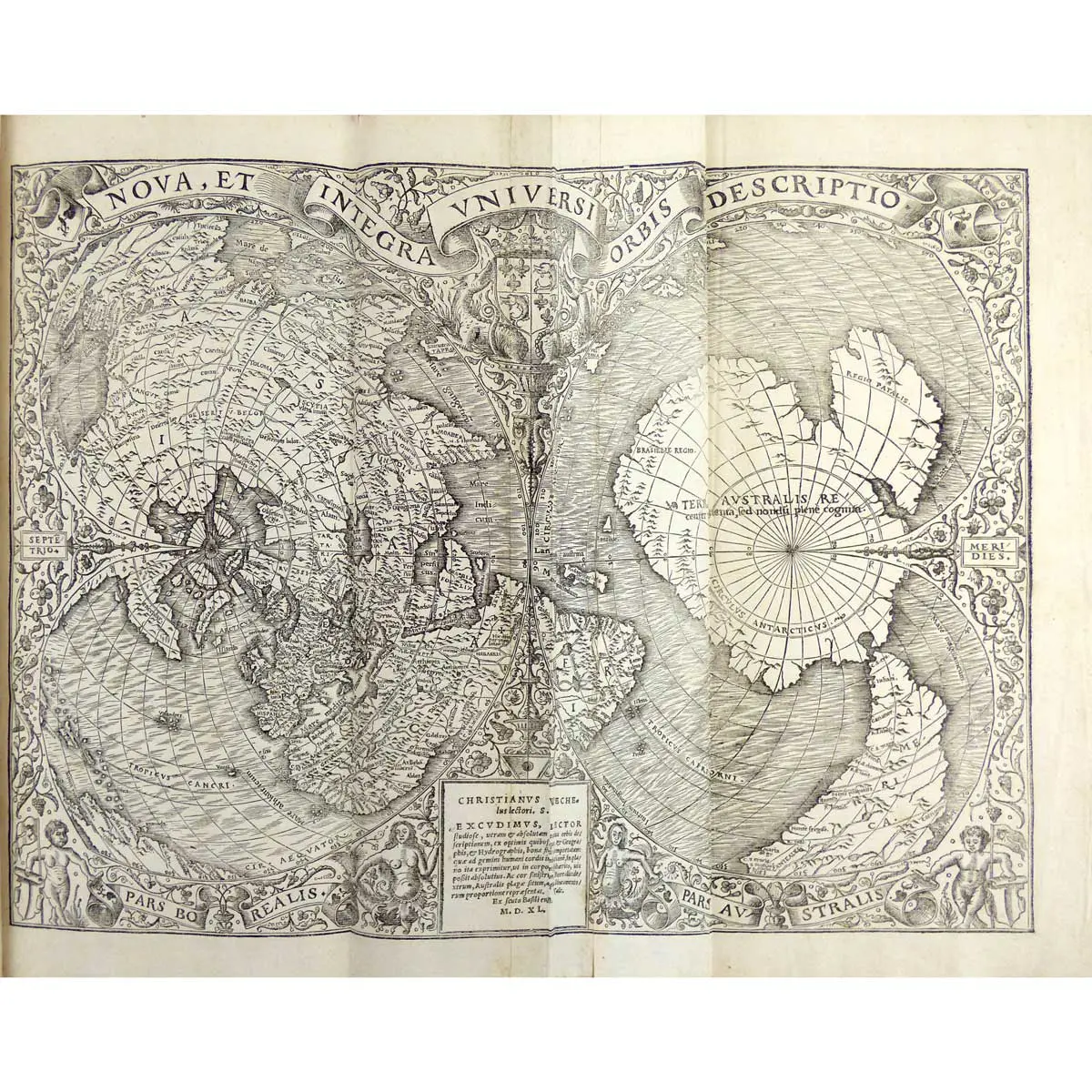
1540. Folio.,Contemporary dark polished calf gilt, rebacked. A Beautiful Copy with the folding World Map by ORONCE FINE, with some restoration to outer margin not affecting engraving and in excellent condition. First Edition of Pomponius Mela’s famous treatise on geography and first to contain “this curious globe-map, divided into two compartments" -- Sabin.
1540. Folio.,Contemporary dark polished calf gilt, rebacked. A Beautiful Copy with the folding World Map by ORONCE FINE, with some restoration to outer margin not affecting engraving and in excellent condition.
First Edition of Pomponius Mela’s famous treatise on geography and first to contain “this curious globe-map, divided into two compartments” — Sabin.
Oronce Fine’s stunning double-cordiform map is a logical departure from the early speculative cartography of Waldseemuller and Ruysch toward the remarkable advances of Gerard Mercator and Michael Tramezinus at the middle of the sixteenth century.
In fact, when Mercator was creating his famous map of the world of 1538, he “turned to works by the brilliant young French mathematician, Oronce Fine, borrowing both the double-cordiform projection and the geography from this remarkable map”. Crane
This is extraordinary map was issued six times from 1531 using the same woodblock. This is the fourth issue and the only change from the 1531 is the date in the legend – now 1540. This is the earliest recognizable depiction of a continuous east coast of North America on a printed map.
Fine, an eminent French cartographer, created this unique double cordiform or heart-shaped projection, emphasizing the northern and southern hemispheres. The European, Asian and African continents were prominently placed in the centre of the left (northern) cordum. However, his treatment of the Americas was somewhat more tentative. By splitting the new World discoveries along the left edge of the northern cordum, it was not obvious that he had depicted these lands as a large peninsula attached to the Asian mainland.
While this depiction contradicted Waldseemüller’s model, Fine did retain the name America, which appears in the southern part of South America, in the right (southern) cordum. This portion of the map is dominated by a continent that was still speculative. Fine labeled it, “Terra Australis,” based on Magellan’s relatively recent passage through the strait at the southern tip of South America. Fine’s use of a single cordiform projection in 1519, as well as this use of the double cordiform projection, introduced a tradition of similar world maps throughout the 16th century. While the projection has a mathematical basis, it presents a visually pleasing map. It is also conceivable, since the heart was a widespread Christian symbol, that the use of the heart-shaped projection added religious meaning to the contents of the map.
The North American continent remains an extension of Asia much along the lines of Contarini and Ruysch; however monumental discoveries have forever altered the coastlines. Fine has extended the eastern coast of North America southward beyond the discoveries of Gomes and Ayllon to a peninsular outline of Florida, which is named, and a reasonable depiction of the Gulf coast as described by Pineda in 1519. This is the earliest recognizable depiction of a continuous east coast of North America on a printed map. The South American continent is admirably depicted incorporating discoveries by the Portuguese, including Ferdinand Magellan. The Isthmus of Darien is shown and named as well as the Pacific Ocean, which appears as Mare Magellanicum. The west coast of Mexico, although continuous with Asia, is the earliest record on a printed map of the discoveries of Hernando Cortes.
Pomponius Mela wrote the first systematic geography in Latin literature, datable to 43 A.D. De orbis situ (“A Description of the World”), also known as De chorographia
(“Concerning Chorography”). Written about 43 or 44 ad, it remained influential until the beginning of the age of exploration, 13 centuries later. Though probably intended for the general reader, Mela’s geography was cited by Pliny the Elder in his encyclopaedia of natural science as an important authority.
Mela’s work relied on many observations by contemporary navigators and explorer and was unique among the ancient geographies in that it divided the Earth, which Mela placed at the centre of the universe, into five zones: a northern frigid zone, a northern temperate zone, a torrid zone, a southern temperate zone, and a southern frigid zone. The two temperate zones were habitable, but only one, the northern, was known. The southern was unattainable by people of the north because of the necessity of passing through the unbearable heat of the intervening torrid zone in order to reach it. According to Mela, the ocean surrounding the Earth cut into it in four seas, the most important being the Mediterranean. He avoided technical details, such as distances, but usually included short phrases describing the places mentioned.
Less was said of familiar regions than of distant countries, where even fabulous material was included.
He is the first to name the Orcades or the Orkney Islands, which he defines and locates fairly correctly. Of northern Europe his knowledge was imperfect, but he speaks of a great bay (“Codanus sinus”) to the north of Germany, among whose many islands was one, “Codanovia,” of pre-eminent size; this name reappears in Pliny the Elder’s work as Scatinavia. Codanovia and Scatinavia were both Latin renderings of the Proto-Germanic *Skaðinawio, the Germanic name for Scandinavia
Mela’s descriptive method follows ocean coasts, in the manner of a circumnavigation, probably because it was derived from the accounts of navigators. He begins at the Straits of Gibraltar, and describes the countries adjoining the south coast of the Mediterranean; then he moves round by Syria and Asia Minor to the Black Sea, and so returns to Spain along the north shore of the Euxine, Propontis, etc. After treating the Mediterranean islands, he next takes the ocean littoral—to west, north, east and south successively—from Spain and Gaul round to India, from India to Persia, Arabia and Ethiopia; and so again works back to Spain round South Africa. Like most classical geographers he conceives of the continent as surrounded by sea and not extending very far south.
There is an authoritative work by F.E.Romer ‘ Pomponius Mela’s Description of the World’. Describing his Geography and Chorographia.
Crane, Mercator, p. 61; Sabin, 63960; Shirley, The Mapping of The World, 66