Marshall Rare Books
Description des Indes Occidentales, qu'on appelle aujourdhuy le Nouveau Monde: Par Antoine de Herrera, Grand Chroniqueur des Indies, & Chroniqueur de Castille: Translatee d'Espagnol en Francois. A la quelle sont adjoustees Quelques autresDescriptions des mesmes pays, avec La Navigation du vaillant Capitaine de Mer Jaques le Maire, & de plusieurs autres…
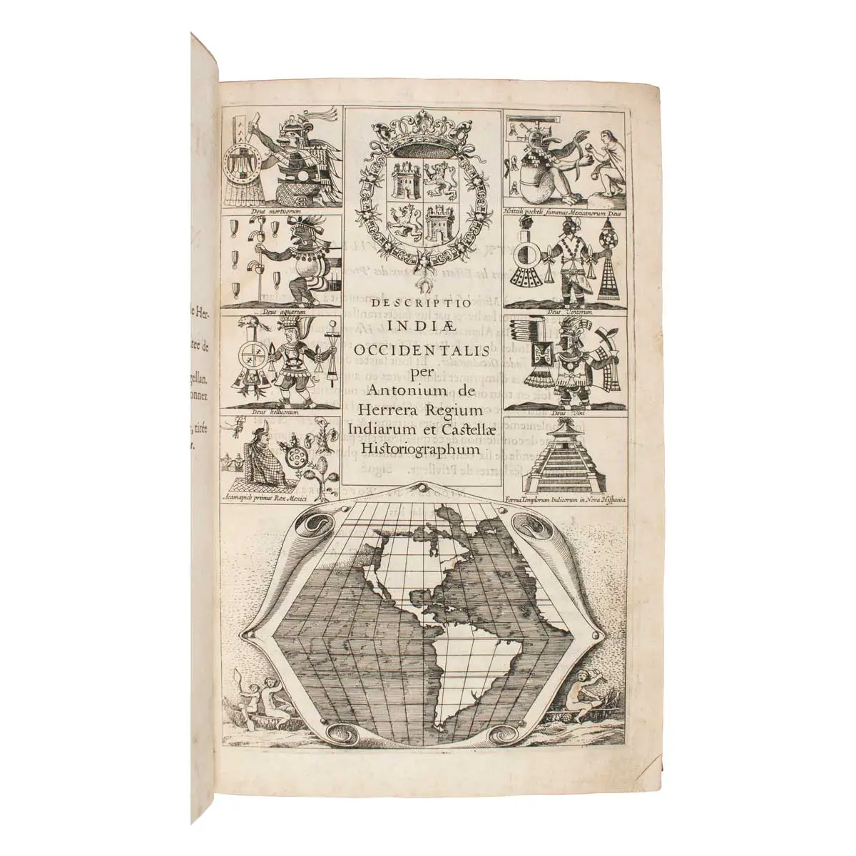
First edition in French, First Issue, Amsterdam imprint, Four editions of this work were published in 1622, including French (imprint of Amsterdam only, Latin, and Dutch. The engraved title has the first printed map showing California as an island.
Amsterdam, M. Colin, 1622.[First Issue of French Edition],Folio (28,5:20 cm), Contemporary tan calf , spine with elaborate gilt fleurons, with printed and engraved allegorical titles, including the first engraved map with California as an island, [8], 1-103, [1, blank], [6] 107-254 pp., head- and tail-pieces, decorated initials, side-notes; 27 copper-engravings: 22 full-page plates:17 maps and charts (16 double-page, 1 folded), 5 text engravings (scenes from Le Maire voyage)
First edition in French, First Issue, Amsterdam imprint, Four editions of this work were published in 1622, including French (imprint of Amsterdam only, Latin, and Dutch. The engraved title has the first printed map showing California as an island.
This edition of Herrera includes the first publication of Jacques Le Maire’s journal of one of the greatest early Pacific voyages and circumnavigations, that of Le Maire and Schouten in 1615 and 1616.
Following the Le Maire account are a list of voyages that went through the Straits of Magellan, beginning with Magellan in 1519-1520 (and including Francis Drake 1577) through the sixteenth century; short vocabularies for Solomon Islands, New Guinea and other South Sea Islands; description of the East Indies by Father Pedro Ordéñezde Ceballos (first published in 1614); and Petrus Bertius’ Descriptíon d’Amerique.
The present edition of Herrera is particularly important because of the second part, the account of Jacob Le Maire’s voyage around Cape Horn and across the Pacific. In 1615, Le Maire sailed for the Australian Company, on behalf of his father, Isaac Le Maire, who hoped to break the monopoly of the Dutch East India Company’s trade route to the Spice Islands. Departing in June from Texel in the Netherlands in two ships, the Eendracht and the smaller Hoorn, Le Maire was seeking a new route to the Spice Islands that would circumvent the Dutch East India Company’s monopoly on the Strait of Magellan route. The Hoorn was lost to fire in Patagonia, but the Eendracht continued around Cape Horn (which was named for both the lost ship and the hometown of the Eendracht’s captain, Willem Cornelis Schouten). By discovering and rounding Cape Horn, Le Maire not only avoided the Strait of Magellan but also dispelled the myth of a great southern continent joined to South America and changed the future of navigation. Le Maire made several significant discoveries in the South Pacific, including proving that the island of New Guinea was not part of a larger landmass. In September 1616, the Endracht reached the Dutch East India Company headquarters on Ternate in the Moluccas. They were initially welcomed but later ran foul of Company officials who were jealous of their monopoly. La Maire, Schouten, and other members of the Company were shipped home from Batavia, but Le Maire died at sea on the way and his journals came into the hands of the Dutch East India Company. Edited versions were published for the Company under the authorship of Willem Schouten and Joris van Spilbergen, but after a long legal process, Isaac Le Maire was able to regain custody of his son’s journals and publish them here, making this the first genuine edition of Le Maire’s voyage. Le Maire’s is one of the great early accounts of circumnavigation and Pacific exploration.
Fourteen of the maps are from Herrera’s original edition the Descripcíon (atlas) published at Madrid in 1601. Map Descripçion de las Yndias del Norte, which is listed in Martin & Martin in their book on maps of Texas and the Southwest (Plate 7), is changed only slightly from its first appearance in the 1601 edition of Herrera. The geography is the same, and only some lettering and decorative details have been altered.
Map & Plate list.
Engraved pictorial title page with map of the Americas, eight vignettes of Pre-Cortesian deities, Aztec temple, arms of Spain, and at bottom the untitled map of the Americas within decorative scroll border, showing California as an island (10.5 x 14.5 cm). Burden, The Mapping of America 195: “This small map’s chief claim to fame is in being the first map to delineate California as an island…. [The map] does depict confidently a Northwest Passage.” California 49, mentioned in entry for Map 9: “In 1622, California appeared as an island [as a title vignette on] Herrera’s DescriptioIndæ Occidentalis.” Leighly, California as an Island, Plate 1 & pp. 27-31: “Fray Antonio de la Ascensión, who accompanied the Viscaíno expedition in 1602, drew a map showing California as an island and sent it to Spain in 1620. It is thought that Dutch pirates captured a copy of the map from a Spanish ship a few years earlier. Though the maps have disappeared, one or both are presumed to be the main source of the cartographic notion of an insular California. The first known printed depiction of California as an island is this small title page map of America which appeared in the Latin edition of Antonio de Herrera’s Descripción des Indies Occidentales in 1622. Such a map also appeared on the title page of the French and Dutch editions of Herrera’s book the same year.” McLaughlin, p. 126 (first item for title page category): “Earliest representation of California as a large island on map of the Western Hemisphere.” Schwartz, The Mismapping of America, p. 143 & Plate 43 (showing the 1623 title for the Frankfurt edition). Tooley, “Title Pages from 16th to 19th Century,” Plate 15. Wagner, Cartography of the Northwest Coast 291 & pp. 145-146. Wagner characterizes the insular theory applied to the title page map as “rather misleading,” suggesting that the strait might actually be a continuation of the Colorado River (Spanish Voyages to the Northwest Coast of America in the Sixteenth Century, pp. 385-387). However, the general map of America in this work shows California as a peninsula.
[1] Descripcion de las Yndias Ocidentalis 1 [below Tropic of Capricorn at left] Entre los dos Meridianos senalados se contiene la nauegaçion y descubrimeito [sic] que compete a los Castellanos. Plate mark: 22.5 x 31.7 cm. Map of North and South America, with parts of Asia, the Philippines, Europe (Portugal and Canary Islands), etc. California is named and shown attached to North America. Burden 196: “This uncommon map depicts the Papal line of demarcation dividing the world between Spanish and Portuguese spheres of influence. Being Spanish in origin this map naturally favours that country, placing the Philippines and Mollucas some 40° too far east.” Phillips, Atlases 1144. Wagner, The Cartography of the Northwest Coast 290
[2] Descripçion de las Yndias del Norte 2. Plate mark: 21.5 x 29.4 cm. Map of North America, including Central America, the northernmost part of South America, and the Caribbean. Burden 197. Martin & Martin, p. 18n & p. 77n & Plate 7 (1601 edition). Phillips, Atlases 1144.
[3] Description del destricto del audiencia de la Española 3. Plate mark: 21.7 x 29.6 cm. Map of the Caribbean, southern North America to present Port Royal (South Carolina), Florida, and the northern part of South America. Burden 198: “This is one of the more detailed of Herrera’s maps.” Phillips, Atlases 1144.
[4] Descripçion del destricto del audiençia de Nueva España 4. Plate mark: 21.7 x 29.7 cm. Map of Mexico and Central America, including the Yucatan peninsula, present-day Mexico, Durango, Honduras, and Guatemala. Phillips, Atlases 1144
[5] Descripcion del destricto del audiencia de la Nueva Galicia 5. Plate mark: 21.8 x 29.7 cm. Map of part of Central America, including present-day Mexican states of Aguascalientes, Colima, and Jalisco, and parts of Durango, Guanajuato, Michoacán, Nayarit, and Zacatecas. Phillips, Atlases 1144.
[6] Descripcion del audiencia de Guatimala 6. Plate mark: 21.7 x 29.4 cm. Map of part of Central America, including present-day Chiapas, southern Yucatan, Guatemala, Nicaragua, south to Costa Rica and Panama. Phillips, Atlases 1144.
[7] Descripcion de las Yndias de Mediodia 7. Plate mark: 22.1 x 29.4 cm. Map of South America showing the papal line of demarcation, Amazon River, Rio de la Plata, and the Strait of Magellan. Phillips, Atlases 1144.
[8] Descripcion del audiencia de Panama 8. Plate mark: 21.6 x 29.3 cm. Map of the audiencia of Panama, showing rivers and settlements. Phillips, Atlases 1144.
[9] Descripcion del audiencia del Nuevo Reino 9. Plate mark: 21.6 x 29.3 cm. Map of the audiencia of the New Kingdom of Granada, present-day Colombia and Venezuela, locating rivers and settlements. Phillips, Atlases 1144.
[10] Descripcion del audiencia del Quito 10. Plate mark: 21.6 x 29.3 cm.Map of the audiencia of Quito, present-day Ecuador with parts of Peru, Colombia, and Brazil, showing rivers and settlements. Phillips, Atlases 1144.
[11] Descripcion del destrieto del audiencia de Lima 11. Plate mark: 21.7 x 29.6 cm. Map of the audiencia of Lima, present-day Ecuador, parts of Peru, Colombia, and Brazil, including rivers, Lake Titicaca, and settlements. Phillips, Atlases 1144.
[12] Descripcion del audiencia de los Charcas 12. Plate mark: 21.6 x 29.6 cm. Map of the audiencia of Charcas, present-day Bolivia, with some rivers and settlements. Phillips, Atlases 1144.
[13] Descripcion de la provincia de Chile 13. Plate mark: 21.7 x 29.5 cm. Map of the audiencia of Chile with some topographical details, rivers, settlements. Phillips, Atlases 1144.
[14] Descripcion de las indias del Poniente 14. Plate mark: 21.7 x 29.5 cm. Map of the East Indies from Bengal to the Solomon Islands and north to Japan, which is shown as one main island. Phillips, Atlases 1144.
[15] Untitled view from Le Maire voyage, showing Puerto Deseado in present-day Argentina, dated 1615 Decemb. in upper left corner. Plate mark: 19.6 x 16.5 cm. Full-page text illustration on p. 122. Includes scenes of hunting and burial. Men kill and butcher sea lion and seal; other animals shown are llamas and penguins. Bones of a Patagonian giant are being dug up from a graveyard. Key below identifies animals and activities and gives Patagonia as one of the place names. The Dutch reached Puerto Deseado on the estuary of the Rio Deseado in December 1615 where they ran aground. When refitting and preparing for the next leg of the voyage, one of the ships, the Hoorn, was accidentally set on fire while being scorched clean and was destroyed.
[16] Caerte van de Strate ende Passage by Iacobe le Maire ghevonden ende beseyltin’t Zuydoosten Magallansche Straaten….Plate mark: 21.5 x 29.2 cm. Map of Southern tip of South America, Strait of Magellan, and Tierra del Fuego. Located is Cape Horn, discovered and named during the Le Maire voyage to Tierra del Fuego described in the volume. Phillips, Atlases 1144.
[17] Untitled view from Le Maire voyage, showing three vessels and Dutch firing on natives, dated 1616 Avril at upper right corner. Plate mark: 19.9 x 16.6 cm. Almost full-page text illustration on p. 139. The scene shows natives sailing in an outrigger with a lateen sail, while one of them tends a cook fire. Dutchmen rowing a small boat pursue and fire on the native outrigger (Dutch ship Eendracht in background). Key below.
[18] Cocos Eylandt, Isle de Cocos, Verrader Eylandt, Isle des traistres [captioned in sky], view from Le Maire voyage, showing Dutch ship Eendracht and many small boats of the natives at Cocos Island (present-day Tafahi) in the Tonga Islands, dated 1616 May at upper right corner. Plate mark: 20 x 16.9 cm. Almost full page text illustration, on p. 143. The Eendracht is at anchor in the foreground with canoes full of locals trying to board her. In the background are more locals in canoes, and a boatload of sailors battle other natives in canoes. The key below identifies events. Their party was the first to visit the Tonga Islands by Europeans.
[19] Untitled view from Le Maire voyage, showing a celebration of Dutch and natives, dated 1616 May in upper left corner. Plate mark: 20 x 16.8 cm. Full-page text illustration on p. 150. Islanders give a feast for sailors with “Ceremonies bien estranges.” Foreground group of natives palavering; in the background another native group pours a beverage into a bowl as a nearby group of Europeans plays trumpets and a drum. Behind them people are feasting under a thatch-roofed pavilion. Key below identifies the events.
[20] Hoornse Eijlant Isle de Hoorn [captioned in sky], p.156, view from Le Maire voyage showing Dutch ship at Horne Islands, dated 1616 May in upper left corner. Plate mark: 19.7 x 16.7 cm. Almost full-page text illustration. The Dutch replenish their water supply. The Eendracht is at anchor in the bay of a tropical island with natives on the shore and in boats. In the foreground a boatload of Dutchmen appears to take potshots at the locals, two of whom are falling off their boat into the water. The Horne Islands (Futuna and Alofi) are in the Territory of Wallis and Futuna, a Polynesian French “overseas collectivity” in the South Pacific. Key below. The Le Maire expedition discovered these islands
[21] Caerte vande zeylage van Jacob le Maire over de Zuydzee…. Plate mark: 21.8 x 52.6 cm (folded map on two sheets).Chart mapping part of the route (around the Horn and across the Pacific) taken by Schouten and Le Maire.
[22] Caerte vande Landen vande Papouas ofte Nova Guinea nae de beseijlinge enondecking van Iacob le Maire gedaen in den Iare 1616. Plate mark: 21.4 x 29.3 cm. Small sea-chart of the Moluccas islands Gilolo, Ceram and Boru, and the north-west coastline of Papua, New Guinea. Shows track of Le Maire and Schouten on the 1615-1617 expedition to evade the trade restrictions by Dutch East India Company by finding a new route to the Pacific and the Spice Isles.
JCB I (2, 1600-1658), p. 166. Brunet III, cols. 132-133. Burden, The Mapping of North America 195-198 (illustrated). Cox I:41n. European Americana 1622/68. Hough, Lesser Antilles 22n. Kroepelien 561 (Latin edition). Leclerc, Bibliotheca Americana (1867) 708; (1878) 280. Lowery 105. Medina, Biblioteca Hispano-Americana 455n. Sabin 31543 (& 14351n). Spence 587. Streit II:1532. Tiele-Muller, Memoire bibiographique sur les journaux des navivateurs néerlandais 296. Tooley, California as an Island 107 (Plate 15). Wagner, Cartography of the Northwest Coast, pp. 145-146 & No. 291. Wagner, Spanish Southwest 12b.
Books you may also like
Histoire de la navigation aux Indes Orientales. Contenant diverses Descriptions des lieux iusques à présent descoverts par les Portugais